Petroglyphs at the Mouth
of Black Canyon 

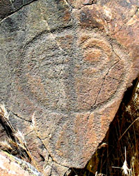 Black Canyon was probably a prehistoric freeway. It provided Indians with a relatively easy eight mile route between Harper Lake, located near the 2,400' mouth of the canyon, and its origin near Superior Lake at an altitude of 3,000'. Archaeologists have not found evidence of extensive village sites within the canyon, but its frequent use and importance can be inferred from the voluminous petroglyphs found throughout the route. Were these puzzling embellishments a record of family clan migrations, astronomical observations, hunting magic or were they religious in nature? We will never know. But that doesn't mean that we can't be thrilled at their discovery!
The Dzrtgrls, confirmed petroglyph junkies, were off on a day trip to explore three petroglyph sites at the southern entrance to the canyon. In the cab of the Lizardmobile we had an excellent guide by Wilson G. Turner, The Rock Art of Black Canyon. Turner, and a host of volunteers, began a project in 1978 that would record every petroglyph in the canyon and adjacent areas. This monumental task was finally finished in 1994. The guide contains a staggering 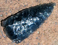 amount of information. Although we eventually would like to visit the majority of the sites that Turner uncovered, we decided to pick a few near the mouth of the canyon to start out with. The sites we chose for today were Black Knob, Smokey Knoll, and a very interesting small site at Tortoise Mountain. Click on the photo link below to join us in some rock scrambling that will turn up some interesting petros and a fabulous obsidian arrowhead.