Howe's Tank Revisited & More 

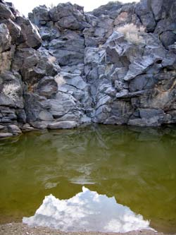 All
the rain we've had in Southern California lately left us
wondering what Howe's Tank would look like with water in
it. (For our first encounter with Howe's Tank click
here.) After all, this had to be
part of the magic that brought the Indians to the site
in the first place. So a trip was born! And
to make a long story short, it certainly did have water
in it, but it was frozen! This was even better! The
Tank itself continues to amaze us with the sense of awe that
it instills. But we also wanted to do a detailed
exploration of the general area. What else, if anything,
was out there? We had found some areas on the topo
map that interested us, and we had those coordinates loaded
into the GPS. Before the day was over we would hike
over eight miles across a lava flow landscape paved with
unstable rocks from the size of eggs to basketballs. We
would totter, slide, stumble, trip and stub our way
to some substantive discoveries. We would find an undisturbed
grouping of rock rings, as well as several other petroglyph
locations, some containing big horn sheep representations. We
also found some other natural tanks and a truly monumental
drop-off at the edge of the lava flow. Interested? If
you want to come along, lace up those boots and shoulder
your pack, and click on the photo link below!
All
the rain we've had in Southern California lately left us
wondering what Howe's Tank would look like with water in
it. (For our first encounter with Howe's Tank click
here.) After all, this had to be
part of the magic that brought the Indians to the site
in the first place. So a trip was born! And
to make a long story short, it certainly did have water
in it, but it was frozen! This was even better! The
Tank itself continues to amaze us with the sense of awe that
it instills. But we also wanted to do a detailed
exploration of the general area. What else, if anything,
was out there? We had found some areas on the topo
map that interested us, and we had those coordinates loaded
into the GPS. Before the day was over we would hike
over eight miles across a lava flow landscape paved with
unstable rocks from the size of eggs to basketballs. We
would totter, slide, stumble, trip and stub our way
to some substantive discoveries. We would find an undisturbed
grouping of rock rings, as well as several other petroglyph
locations, some containing big horn sheep representations. We
also found some other natural tanks and a truly monumental
drop-off at the edge of the lava flow. Interested? If
you want to come along, lace up those boots and shoulder
your pack, and click on the photo link below!Note: Don
Austin, at the superb www.petroglyphs.us and www.sandcarveddesigns.com,
passed along some information about the name of the Tank. It
seems that this came from a "survey report written by Gerald
Smith in the late 1950's. Smith was an archaeologist
who did extensive work in the Mojave and Howe was Smith's hiking
companion who is credited with a lot of archaeological photography
from those times." Don goes on to say that he heard
a story once that "it was Howe who first recorded the site
in the 1940's and later got Smith to come and do a more thorough
study."