Cady Mountains Rockhounding & Mesquite
Springs Petroglyphs
 Most rockhounds avoid the deserts
in the summer. It gets very, very hot. October is usually “opening
month” for forays into these geological wonderlands. However, the
Dzrtgrls were bored, and we took a chance in late August with a trip
to the Cady Mountain area.
Most rockhounds avoid the deserts
in the summer. It gets very, very hot. October is usually “opening
month” for forays into these geological wonderlands. However, the
Dzrtgrls were bored, and we took a chance in late August with a trip
to the Cady Mountain area.
Our gateway to the Cady Mountains was the truck stop town of Ludlow, about forty-five miles east of Barstow on Interstate 40. Here you can top up your tank before going off road, and the presence of a Dairy Queen makes this one of our favorite “trailheads.” We arrived at 9:00 AM and decided to spend the morning collecting colorful jasper, chalcedony, and rhombohedral calcite crystals in the southern Cadys. We would then swing by the Dairy Queen again before heading north through Broadwell Dry Lake, along the old Tidewater and Tonopah railroad grade, and end the day with a hunt for petroglyphs at Mesquite Springs before camping at Mesquite Dry Lake. Sunday morning we planned to explore the Old Dominion Mine for copper ores such as malachite, cuprite, bornite and chrysocolla; and finally we hoped to find the home of the elusive flame and lace agate that we had heard so much about.
The morning went well. It hadn’t
gotten unbearably hot yet. We drove north out of the Dairy Queen parking
lot onto the dirt road and turned left onto the powerline road at about
two miles. We used Gem Trails of Southern California by James Mitchell
as our reference. Pages seventy-two and seventy-three deal with the Southern
Cadys. We started
by exploring some of the extensive diggings around the old barite mine
on your right as you first approach the hills. Then we made a stop at
site “A.” We almost didn’t bother. It’s one of
the most nondescript hills imaginable. But once you hike over, you realize
that it is literally paved with jasper. The majority is a bit muted,
but there is much banding, and some very nice pieces can be found. If
you turn north at site “A” you will continue up the wash
into a very colorful 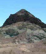 area. Patches of white, red and green hint at some
good collecting. We were after the rhombohedral calcite crystals that
originate high on the hill at site “B” where the obvious
contact zone is. This involves some major uphill hiking through loose
talus. The rewards are individual crystals as well as clusters. From
there we returned to the powerline road and continued on to the easily
spotted brilliant red and yellow hills that comprise site “C.” They
are not far from the road, but it was about 105 degrees now and we moved
slowly. The hills are a candy store of vivid jasper in almost all colors,
solid and banded. Our sacks were heavy as we retreated to the air conditioned
comfort of the Jeep Liberty. We turned north again past site “C” and
worked up a wash to an area of jasper and agate and an old mine. This
was an interesting area to explore. The area behind the mine head frame
forms a natural tank and opportunistic plants jarred us with their vivid
green. Up to now the sites could be visited in a passenger car, but the
powerline road got worse as we traveled west, and this last site was
best accessed with 4wd. We continued on to site “E,” but
it was really hot and we decided to take the downhill road south to the
National Trails Highway and head back east to the Dairy Queen for a Blizzard.
Ahhh….this is the life!
area. Patches of white, red and green hint at some
good collecting. We were after the rhombohedral calcite crystals that
originate high on the hill at site “B” where the obvious
contact zone is. This involves some major uphill hiking through loose
talus. The rewards are individual crystals as well as clusters. From
there we returned to the powerline road and continued on to the easily
spotted brilliant red and yellow hills that comprise site “C.” They
are not far from the road, but it was about 105 degrees now and we moved
slowly. The hills are a candy store of vivid jasper in almost all colors,
solid and banded. Our sacks were heavy as we retreated to the air conditioned
comfort of the Jeep Liberty. We turned north again past site “C” and
worked up a wash to an area of jasper and agate and an old mine. This
was an interesting area to explore. The area behind the mine head frame
forms a natural tank and opportunistic plants jarred us with their vivid
green. Up to now the sites could be visited in a passenger car, but the
powerline road got worse as we traveled west, and this last site was
best accessed with 4wd. We continued on to site “E,” but
it was really hot and we decided to take the downhill road south to the
National Trails Highway and head back east to the Dairy Queen for a Blizzard.
Ahhh….this is the life!
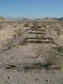
After we revived it was north again to Broadwell Dry Lake, and then along the historic Tidewater and Tonopah railroad grade as it runs due north to the Mesquite Hills, about twenty miles from Ludlow. The road is well graded with some erosion, but just through the Mesquite Hills it’s 4wd time as major erosion has created several challenges. With Niki at the wheel, the Liberty surprised us with its ability, and we headed toward the green athol trees ahead on the left, which mark the location of Mesquite Springs. Long before the white man, this remote site was a large Indian camp due to the reliable water provided by the springs, and the associated game and mesquite beans, which also thrived in this little oasis. Although no water was flowing during our visit, the greenery was significant, and the old bathtub represents optimistic hope for the future! Just behind the spring, and over the old T & T railroad berm, are the petroglyphs. They are spread throughout the jumbled rocks, all the way to the top of the hill. Many trails radiate from the springs and it would be fun to explore them in cooler weather! The Indians, of course, were gone in 1905 when the T & T railroad started service from Ludlow to Goldfield, Nevada. It served the miners and desert communities until 1940. It provided the shortest, cheapest and fastest route from the Death Valley region to Los Angeles and San Francisco. In 1943 the rails were salvaged, but in isolated spots along the old roadbed the ties provide mute testimony to a bustling past. Mesquite Springs was an important water stop for the steam engines. It’s amazing that so much happened here in the past, yet it is so remote and quiet today.
As we retraced our route toward Mesquite Dry Lake, we spotted the mysterious “Desert Megaphone” that Bill Mann discusses on pages forty-four and forty-five of Guide to 50 Interesting and Mysterious Sites in the Mojave Volume 1. It certainly is an oddity, and the effort to mount it in this remote location must have been prodigious. We’ll be back on a cooler day to hike up to its perch on the ridge.
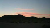 Mesquite dry lake was beautiful
in the late afternoon sun. We were surprised to find a tidy cabin complete
with pickup truck and no trespassing sign at the western “shore” of
the lake. We headed to the far eastern part to set up camp. It was too
hot for a fire, so we enjoyed a simple dinner of stew on the Primus stove
and watched the sunset. We set up the spotting scope to do a bit of stargazing,
but the full moon was just too bright. A hot, dry wind blew most of the
night, but it did cool a bit toward morning. We took advantage of the
brief respite from the heat and packed up and retraced our route south
toward Ludlow. At the northern tip of Broadwell Dry Lake we made a side
trip west to the Old Dominion Mine. The road to the mine isn’t
that bad, but if you continue on it past the mine you’d better
put it in low range! Don’t plan to drive all the way to the mine.
It’s way up a very steep hillside. You can see the faint trail
leading up to the tailing dump. It’s worth the climb, though. There
are several adits, and the dump is full of various types of copper ore
samples. The view is also spectacular! Yes, that’s your car way
down there!
Mesquite dry lake was beautiful
in the late afternoon sun. We were surprised to find a tidy cabin complete
with pickup truck and no trespassing sign at the western “shore” of
the lake. We headed to the far eastern part to set up camp. It was too
hot for a fire, so we enjoyed a simple dinner of stew on the Primus stove
and watched the sunset. We set up the spotting scope to do a bit of stargazing,
but the full moon was just too bright. A hot, dry wind blew most of the
night, but it did cool a bit toward morning. We took advantage of the
brief respite from the heat and packed up and retraced our route south
toward Ludlow. At the northern tip of Broadwell Dry Lake we made a side
trip west to the Old Dominion Mine. The road to the mine isn’t
that bad, but if you continue on it past the mine you’d better
put it in low range! Don’t plan to drive all the way to the mine.
It’s way up a very steep hillside. You can see the faint trail
leading up to the tailing dump. It’s worth the climb, though. There
are several adits, and the dump is full of various types of copper ore
samples. The view is also spectacular! Yes, that’s your car way
down there!
Back on the dirt road to Ludlow we had one last plan. At the faded white sign that tells of the toxic waste dump once planned for the area, we took the trail to the west and headed for the hills in the distance. Nobody had been on this one recently. It quickly turned into a wash, and with some creative driving we finally made it to our objective. The site had some nice chalcedony and a great deal of agate fragments and nodules. We haven’t cut any of the agate yet, but after some fieldwork with the rock hammer it’s doubtful if any of it is the prized lace or plume variety. Oh well, we have another spot in mind and as the weather cools we’ll give it another try!
All in all, this was a much-needed escape from the city. We found great stuff, saw some remote locations, and really enjoyed the Blizzards and double cheeseburgers at Dairy Queen!